Skip to content →

Category: photographs

Looking down (#16 in series: facing Grand Canyon’s South Rim)


Our early autumn morning helicopter flight in October 2012 made it easy for us to see how very different were the Grand Canyon’s North Rim and South Rim.

The average “straight line” distance from South Rim to North Rim: 16 kilometres.

Maximum straight line distance: 28.8 kilometres.

However, the road distance from South Rim Village to North Rim Village is 346 kilometres; given favourable weather, a car’s driver should allow five hours!

Leave a Comment

Looking down (#15 in series: wide-angle, aerial view of Grand Canyon)


The Grand Canyon’s  primary “sculptor” – the Colorado River – is on the left hand side of the image.

From this October 2012 photo’s helicopter vantage point, the Colorado’s waters were rendered invisible by early morning shadows, but the river’s course was readily apparent.

As you would expect, the Grand Canyon National Park’s “stats” are impressive; click here to see many of them.

Leave a Comment

Looking down (#14 in series) …to the Colorado

The first three of this post’s four photos were all taken from a helicopter, looking down into the Grand Canyon.

That canyon’s “lead author” runs along its “floor” – the Colorado River.

As the Colorado’s excellent Wikipedia entry notes, the United States’ fifth-longest river is one of the most controlled and litigated river systems in the world.

This once-wild, formerly much-mightier river has become an ailing shadow of its former self; irrigators and thirsty cities have tamed, maimed and nearly drained it.

One Comment

Looking down (#13 in series – trees “5”: grand, surprising)


One of the world’s most famous, most oft-photographed natural attractions can still greatly surprise even an allegedly “well-informed” first-time visitor.

This post’s photos were both taken from a helicopter, looking down at the northern “wall” of  what many humans (wrongly) believe is “our” planet’s biggest and/or deepest canyon.

The Grand Canyon is neither the biggest in volume, nor the deepest, nor the longest, nor the widest, but it is very grand.

Some parts of the Grand Canyon are a deal “leafier”, cooler, and wetter than most people imagine.

Leave a Comment

Looking down (#12 in series…on Australia Day)


As you probably know, on Australia Day 2026 circa 2,500 people took part in an entirely peaceful “Invasion Day” rally/protest in Perth’s Forrest Place.

Adjacent to Forrest Place, and overlooking it, is Forrest Chase’s elevated walkway – from which an IED (improvised explosive device) was hurled.

Had it worked as intended, the probable consequence would have been multiple injuries…perhaps, fatalities too.

By virtue of the bomb-throwing occurring in Perth, rather than in Sydney or Melbourne – and the bomb’s failure to detonate – Australia’s Sydney-centric, so-called “national” media were regrettably but predictably slow to grasp the seriousness of this profoundly disturbing incident.

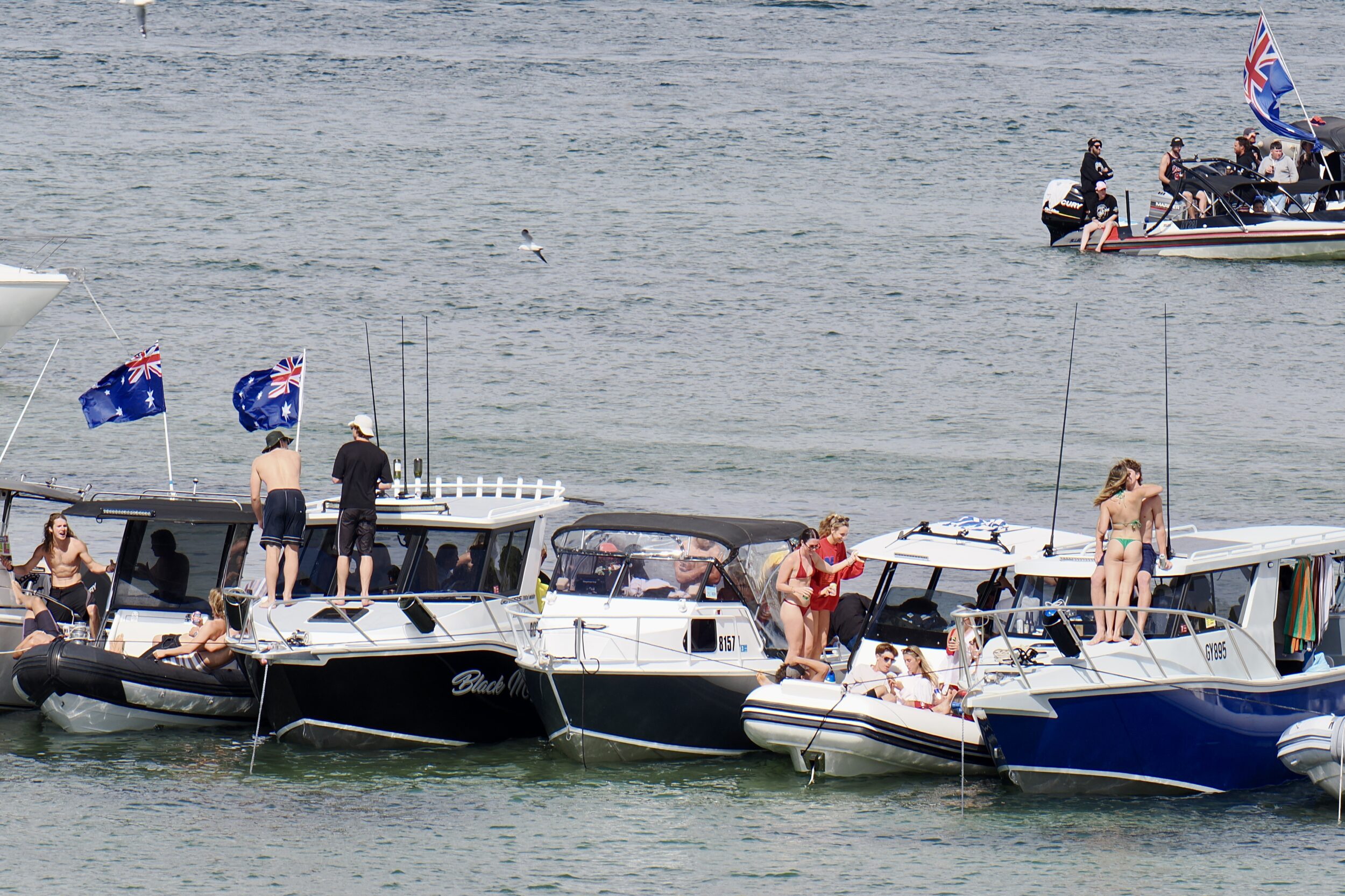
Meanwhile, that afternoon, my beloved and I were blissfully ignorant of what had happened, as we enjoyed a long walk along the Rocky Bay cliff line, above the Swan River.

The waters immediately below the North Fremantle cliffs (where river and ocean are  separate, but very close to each other) were thronged with Australia Day revellers, and many millions of dollars worth of boats.

Goodwill abounded.

Leave a Comment

Looking down (#11 in series – trees “4” – Spring Gully)


This sequel to #10 in this series looks down into the actual gully in Spring Gully Conservation Park.

Its  own website  explains the Park’s raison d’être:

Spring Gul­ly Con­ser­va­tion Park was set aside to con­serve the west­ern­most pop­u­la­tion of the red stringy­bark Euca­lyp­tus macrorhyn­cha. This park is the only reserve in South Aus­tralia to con­tain this par­tic­u­lar species. 

Alas, Spring Gully’s “hero” species is now in serious trouble in its sole South Australian “refuge”.

Leave a Comment

Looking down (#10 in series – trees “3”: Spring Gully, South Australia)


Spring Gully Conservation Park is 8 kilometres south of Clare, in South Australia’s mid-north.

From Adelaide, it is a little less than a two hour drive; day-tripping from the city is feasible.

However, the so-called “Clare Valley” (in truth, this distinctive region has more than one valley) is such a rewarding destination that it is a much better idea to base yourself there for at least several days.

As the next post will further explain, Spring Gully is of great “conservation value”, and it is more than a little “vulnerable”.

Meanwhile, enjoy what a ridgetop vantage point can do, late on an autumn day…

Leave a Comment

Looking down (#9 in series: trees “2”, Lake Waikaremoana)


This post’s featured image is another example of how remarkably “different” trees and forests can appear when one is able to look down on them…literally.

I took the above photo from a hilltop/outcrop near the edge of the deepest lake on New Zealand’s North Island.

At 54 square kilometres, Waikaremoana it is that island’s fourth largest lake by surface area, but is #2 in water volume. (#1, in both respects on the North Island, is Lake Taupo. Taupo has the largest surface of any NZ lake. Several of the South Island’s glacially-gouged lakes contain more water)

Waikaremoana is very beautiful, but sees remarkably few tourists, thanks to its “remote” location.

Most of the lake’s rugged surrounds have temperate rainforests that have never been logged.

An astonishing fact: until circa 2,200 years ago this lake simply did not exist!

Leave a Comment

Looking down (#8 in series – trees “1”: temperate rainforest, Australia)


Walking on a forest’s or woodland’s floor often yields a great deal of visual delight, as most living humans have directly experienced.

However, relatively few humans have experienced the pleasure of looking down to a forest’s floor, from forest canopy height, or higher.

The view from “up there” is usually a visual treat in its own right.

In recent decades – across a growing number of nations – the construction of elevated walkways has made that experience newly/readily-accessible to millions.

(such walkways also spare tree roots from the potentially-lethal impact of too-many tourists’ feet compacting the relevant soil)

The very same forest looks astonishingly different, when one’s feet are more than 20 metres above the ground.

Leave a Comment

Looking Down (#7 in series: Kaikoura “4” – a short, speedy journey)


If one were to stand atop the summit of Manakau – the Seaward Kaikoura Range’s highest peak – one would be 2,608 metres above the Pacific Ocean.

In a straight line, that Ocean’s shore would be just 12 kilometres away.

Rivers that rush down steep mountains and then meander across a coastal plain, do not flow in straight lines, but the Kaikoura’s rivers are all very short.

If I have correctly identified the pictured one, it is very steep indeed –  descending 1,900 metres in just 26 kilometres!

(Australia’s longest river – the Murray – descends 1430 metres, over more than 2,500 kilometres)

Leave a Comment